

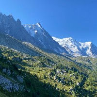
Chamonix Trails featuring Glaciers
The Chamonix Valley features a number of Glaciers and visiting a glacier or seeing one from up close is always a great experience. There are frankly also not that many mountains in Europe that have glaciers and unfortunately all glaciers, including those in Chamonix are receding. If you look at some of the old pictures of Chamonix, you will understand the rate at which these glaciers are disappearing at lower altitude. Luckily, Chamonix has some fast moving glaciers, like the Glacier des Bossons, which drop down quite low and form an integral part of the appeal of the Chamonix Valley. On this page we present our list of the best trails that feature glaciers along the way. We present two ways of findings these trails. Below we feature some pictures of the trails. If you see one you like, then click on it and it will show you where the picture was taken and which trails pass by that location.


Trails in Chamonix to feature Glaciers
The most popular glacier in the Chamonix Valley is the Mer de Glace. This glacier can be visited from Montenvers which is easily accessible using the Montenvers mountain train. There is an ice cave inside the glacier which you can visit and that is a truly unique opportunity which should not be missed. The other glaciers in Chamonix don't enable that level of access but you can still admire them from up close. Here is out list of the best trails that feature glaciers in and around the Chamonix Valley. If you want to do a more detailed trail search then press the search our full database button which will enable you to search our Chamonix trail database on a large number of search criteria.

One of the classic routes in Chamonix which takes you to the junction where the glaciers of Bosson and Taconnaz split. Fantasic up-close views of Mont Blanc
Length
Nearest Town
Starting Point
Route Type
14.98km / 9.30mi
Chamonix
Les Bossons
Out and Back
Elevation +
1561m / 5121ft
Elevation -
1561m / 5121ft
Technical
Hike Duration
Run Duration
7-9 Hours
3-5 Hours
Scenic Beauty
Length
Snack Bar, Big Views, Glacier
Perhaps the most popular route in the Chamonix Valley taking you from the Montenvers station and the Mer de Glace over the Balcon Nord past the Lac Bleu to the Plan l'Aiguille lift station.
Length
Nearest Town
Starting Point
Route Type
7.35km / 4.56mi
Chamonix
Montenvers Train Station
With Lift
Elevation +
471m / 1545ft
Elevation -
103m / 338ft
Technical
Hike Duration
Run Duration
2-3.5 Hours
1-1.5 Hours
Scenic Beauty
Length
Big Views, Refuge, Snack Bar, Family Friendly, Lake, Glacier, With Lift

A wonderful exploration trail getting up close with the Glacier d'Argentiere and a visit to the Chalet Refuge de Lognan. Amazing views and a spectacular glacier.
Length
Nearest Town
Starting Point
Route Type
6.3km / 3.91m
Argentiere
Plan Joran Lift
Loop
Elevation +
474m / 1555ft
Elevation -
474m / 1555ft
Technical
Hike Duration
Run Duration
2-3 Hours
1.25-2 Hours
Scenic Beauty
Length
Refuge, Glacier, Dogs, Big Views, With Lift

This trail takes you to Montenvers via de Buvette des Mottets and then down via de Buvette Caillet. A nice way to get up to Montenvers if you don't want to use the train
Length
Nearest Town
Starting Point
Route Type
11.34km / 7.04mi
Chamonix
Les Planards
Loop
Elevation +
855m / 2805ft
Elevation -
855m / 2805ft
Technical
Hike Duration
Run Duration
4-6 Hours
2-3.5 Hours
Scenic Beauty
Length
Glacier, Snack Bar, Refuge, Big Views, Dogs

This route takes you from the village of Le Tour to the high altitude refuge Albert 1er, right next to the Glacier du Tour
Length
Nearest Town
Starting Point
Route Type
9.31km / 5.78mi
Le Tour
Le Tour
Out and back
Elevation +
862m / 2828ft
Elevation -
862m / 2828ft
Technical
Hike Duration
Run Duration
3-5 Hours
1.5-2.5 Hours
Scenic Beauty
Length
Refuge, Glacier, Big Views, With Lift

A beautiful but pretty tough loop trail taking you from Refuge de Miage up to the Col the Tricot and then to the Refuge de Plan de Glacier via the "Smugglers Path"
Length
Nearest Town
Starting Point
Route Type
10.17km / 6.31mi
Les Contamines
Refuge de Miage
Loop
Elevation +
1181m / 3874ft
Elevation -
1181m / 3874ft
Technical
Hike Duration
Run Duration
4-6 Hours
2.5-3.5 Hours
Scenic Beauty
Length
Refuge, Glacier, Big Views
The Best Trails in Chamonix in other categories
We have many other categories for our selection of the best hiking and trail running trails in Chamonix. Just like this list, all these categories feature hand-picked trails which we feel are the best for that specific category. Have a look at any of these to find your perfect trail.
Lastly, we also have a page that showcases all the trails in our database in text format. This enables you to quickly compare trails and order them by length, elevation gain, name and starting point.